
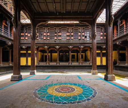
Bhor Rajwada
In one of our drives, we were going through a residential community and really wanted to stop at seeing an extensive and lovely royal residence. We discovered this was the Rajwada of Bhor. The town of Bhor (when an august state) is found somewhere in the range of 51 km south of Pune, near the Bhatgar Dam. The state was established by Shankarji Narayan, who was designated as the Pantsachiv, one of the eight innate priests by Rajaram Chhatrapati in 1697, and was consented to the Dominion of India on 8 March 1948.
The Bhor Rajwada itself is a gorgeous building with large imposing pillars in its courtyard. Many rooms align along the square courtyard and there is an inner courtyard as well, perhaps for the family. The outer larger courtyard area was used for darbars or meeting with the subjects.
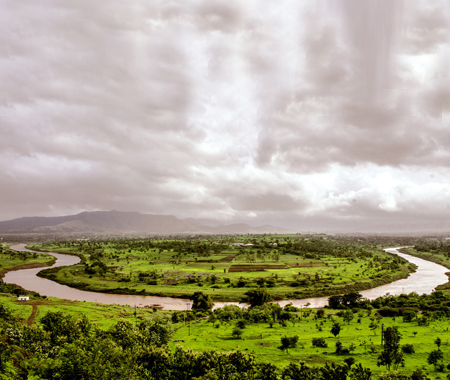
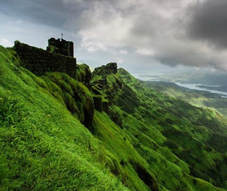
Necklace Point
Necklace Point, Near Bhatghar Dam, Bhor : Necklace Point is 50 kms away from Pune near a place called BHOR. River turned Beautifully creating shape of necklace, Beauty of Nature.
The 'Necklace Point', which flows over the Nira River on the Nirdevghar and Bhatghar dam, is fascinating the tourists. After wearing green shawl on the edge of the corner, it has come to life.
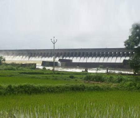
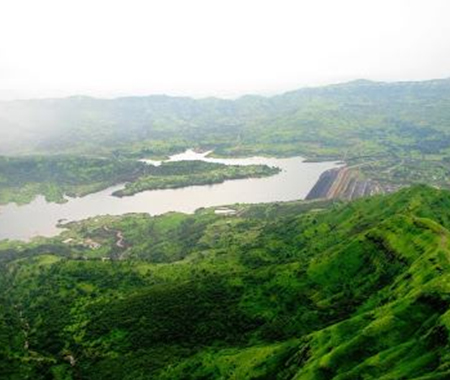
Bhatghar Dam
Bhatghar Dam, is a gravity dam on Yelwanti river near Bhor, Pune district in State of Maharashtra in India. One of the oldest dams in Maharashtra constructed by British.
Erected in 1928, across the river Yelwanti, Bhatghar Dam is an untouched beauty. Beautiful & gigantic with exquisite gardens along with water sports makes this place stunning. It is one of the highest river dams in India.
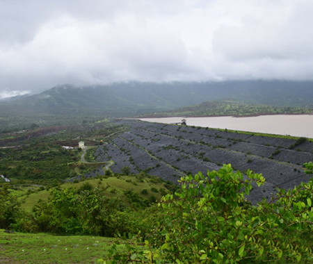
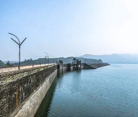
Nira Deoghar Dam
Niradevghar Dam, also written as Nira Deoghar is an earthfill dam on Niira river near Bhor, Pune district in the state of Maharashtra in India. The height of the dam above lowest foundation is 58.53 m (192.0 ft) while the length is 2,430 m (7,970 ft).
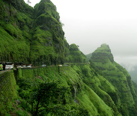
Varandha Ghat
Varandha Ghat is a mountain passage located between NH4 and Konkan in Maharashtra, India for road traffic. Situated on the crest of the Western Ghat mountain ranges, Varandha Ghat is noted for its surroundings, comprising scenic waterfalls, lakes and dense woods.
The Varandha ghat cuts the Sahyadri range to join Bhor to Mahad and is one of the routes between Konkan and Pune. It is 108 kilometres (67 mi) from Pune. This ghat stretches almost 10 kilometres (6.2 mi). The route from Niradevghar Dam up to the start of the ghat has many twists and turns and skirts the backwaters of the dam.
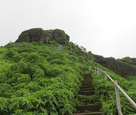
Raireshwar Fort
Raireshwar is a position of recorded significance that is situated towards the south west of Pune close Bhor. This is a lovely place to visit amid the rainstorm or winter season. The stunning perspectives and the sentiment of immaculate nature is simply mind blowing. Perfect place for a one day trek and can likewise be made a multi day trek on the off chance that you intend to visit Rohida and Kenjalgad.
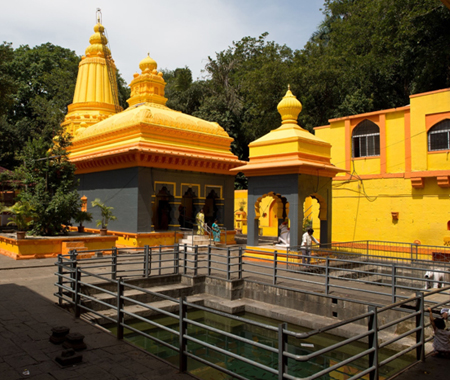
Baneshwar Temple
35 kms from the south of Pune, Baneshwar Temple known as Ban or Jungle, is an old beautiful temple of Lord Shiva. Situated in dense woods and abundant greenery, Baneshwar is a place of scenic beauty and picnic spot. Well tended gardens with small streams add rhythm to it.
Baneshwar is a temple of Shiva located in the village of Nasarapur about 36 km southwest of Pune. It is a pleasant and calm place amidst a jungle. It was recently discovered and hence declared as a small bird sanctuary hosting a decent amount of rare birds with many crowned hornbills seen.
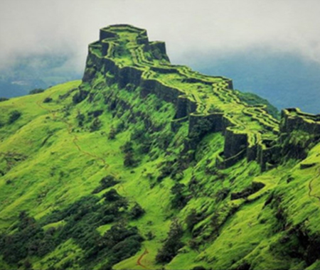
Rajgad Fort
Rajgad is a hill fort situated in the Pune district of Maharashtra, India. Formerly known as Murumdev, the fort was the capital of the Maratha Empire under the rule of Chhatrapati Shivaji Maharaj for almost 26 years, after which the capital was moved to the Raigad Fort. Treasures discovered from an adjacent fort was used to completely build and fortify the Rajgad Fort.
The fort has stood witness to many significant historic events including the birth of Chhatrapati Shivaji's son "Rajaram Chhatrapati", the death of Shivaji's Queen Saibai, the return of Shivaji from Agra, the burial of Afzal Khan's head in the Mahadarwaja walls of Balle Killa, the strict words of Sonopant Dabir to Shivaji.
Torana Fort
Torna fortress is situated in Pune locale and is the best post in pune. The tallness of Torna from ocean level is 1405 meters and offers terrific perspectives of Sahyadri Mountains. When you achieve the best theres much more to find.
Torna Fort, also known as Prachandagad, is a large fort located in Pune district, in the Indian state of Maharashtra. It is historically significant because it was the first fort captured by king Shivaji Maharaj in 1646, at the age of 16, forming the nucleus of the Maratha empire. The hill has an elevation of 1,403 metres (4,603 ft) above sea level, making it the highest hill-fort in the district. The name derives from Prachanda (Marathi for huge or massive) and gad.
Gunjavane Dam
Gunjwani Dam, is an earthfill and gravity dam on Kanand river near Velhe, Pune district in state of Maharashtra in India.
According to Census 2011 information the location code or village code of Gunjavane village is 556671. Gunjavane village is located in Velhe Tehsil of Pune district in Maharashtra, India. It is situated 25km away from sub-district headquarter Velhe and 58km away from district headquarter Pune. As per 2009 stats, Gunjavane village is also a gram panchayat.
The total geographical area of village is 344.49 hectares. Gunjavane has a total population of 703 peoples. There are about 120 houses in Gunjavane village. Pune is nearest town to Gunjavane which is approximately 58km away.
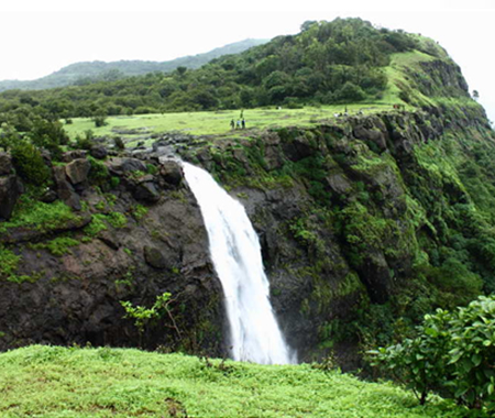
MadheGhat Waterfall
Madhe Ghat is located around 62 km south west of Pune bordering Raigad district and in the vicinity of Torna Fort, Rajgad, Raigad Fort and backwaters of Bhatghar dam. The name of this waterfall is Laxmi Waterfall.
It is about 850 meters above sea level and situated in dense forests behind Torna Fort. From this place, you can have a view of vast area such as Raigad fort, Lingana, Varandha ghat and Shivthar Ghal. This place is cold and is a developing hill station. In history, when the great warrior Narveer Tanaji Malusare died in the Sinhagad battle, his body was to be taken for last rites in his native village Umrath near Poladpur. Tanaji Malusare's funeral procession was taken to his native place from this Madhe ghat route The road at Madhe Ghat is quite steep and muddy. Also there are no hotels above and the area is still under development.
Panshet Dam
Panshet Dam, also called Tanajisagar Dam, is a dam on the Ambi river about 50 km (31 mi) southwest of the city of Pune in western India. The dam was constructed in late 1950s for irrigation and, along with three other dams nearby, Varasgaon, Temghar and Khadakwasla, it supplies drinking water to Pune. Panshet Dam burst in its first year of storing water on 12 July 1961, when the dam wall burst, because of the total absence of mandatory reinforced cement concrete (RCC) strengthening, causing massive flooding in Pune. An estimated 1,000 people died from the resulting flood.
